Duct bank under Ayers Street medical pad
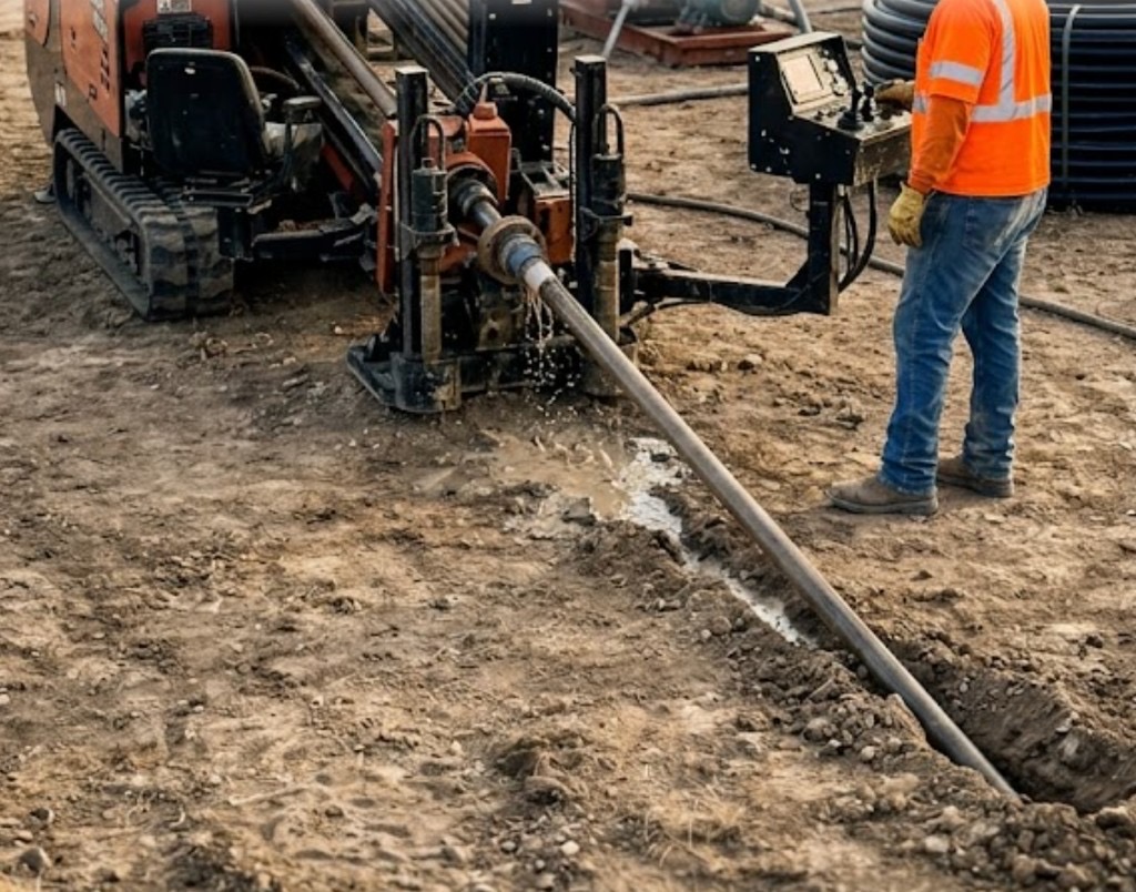
Post-paving TI on Ayers and Staples cannot trench across patient parking to reach switchgear. HDD links vaults under asphalt with entry pits offset from primary access — parking stays partially open.
Corpus Christi, TX · Nueces County
Steerable HDD through coastal sand, Nueces Bay adjacency, and port industrial security — Corpus Christi directional drilling with Gulf fluid programs and hurricane-season scheduling.
Horizontal directional drilling in Corpus Christi deals with coastal sand lenses, shell hash, and high groundwater near Oso Bay, Flour Bluff, and Padre Island. Calallen homeowners preserve driveways when laterals fail; refinery-corridor contractors place conduit under process roads without shutting owner access.
Nueces County is not inland clay — bore collapse in loose sand, bay wind on MOT, and port security orientation define production differently from Dallas or San Antonio. Directional Boring Texas tickets Texas 811, coordinates port owner access when required, and quotes TxDOT Corpus District lead time on I-37 and SPID before pits open.
Real Nueces County angles — not generic statewide copy.
Post-paving TI on Ayers and Staples cannot trench across patient parking to reach switchgear. HDD links vaults under asphalt with entry pits offset from primary access — parking stays partially open.
SPID properties need sand-stable bore paths and corrosion-aware materials near salt air. Steerable bore from cleanout to Corpus Christi Water tap preserves shell driveways open-cut would fracture.
TxDOT Corpus District relocations stack under hurricane-route ROW. HDD narrows closure footprint — coastal wind-stable MOT scoped before rig booking.
Refinery and port periphery jobs layer safety orientation, escorts, and corrosion-aware specs. Quoted upfront — not added at the security gate.
Corpus crews walk alignment with AEP Coastal and Corpus Christi Water maps. Entry pits account for loose sand collapse risk; mud weight and ream pacing manage fluid loss in high groundwater — not blackland assumptions. Near bays, shoring and dewatering may apply. Hurricane season gates low-lying canal entries when storm risk is elevated.
Coastal sands, shell hash, and soft clays with high groundwater near bays and canals — different steering and fluid plans than inland Texas.
Nueces County coastal profiles feature loose sands, shell layers, and soft clay with high water tables near bays. Sands require careful fluid program to prevent collapse; ream stages may be shorter and more frequent. Shell hash accelerates wear. Inland Calallen and Annaville see firmer clay — still coastal-influenced groundwater. We do not use inland clay assumptions for beach-side bores.
Gulf humidity, coastal wind, hurricane evacuation routes, and salt exposure affect restoration materials and work windows in Corpus Christi.
Hurricane season elevates schedule risk June through November — owners want utilities in before peak season. Coastal wind affects lane closure setups on high bridges. Sudden tropical downpours flood low entries near canals. Salt air favors corrosion-resistant hardware on exposed pit structures.
City of Corpus Christi Engineering, Nueces County, TxDOT Corpus District, port authority adjacency, and hurricane route priorities on I-37.
City of Corpus Christi Engineering permits ROW work. Nueces County handles unincorporated areas. TxDOT Corpus District governs I-37, US-181, and SPID crossings. Port of Corpus Christi properties require owner coordination. Hurricane evacuation route work may face seasonal restrictions during peak storm preparedness windows.
Open-cut through island shell drives and port process roads destroys hardscape and owner access faster than the bore costs. HDD wins on SPID, medical corridor TI, and industrial pads.
Length, diameter, soil/rock, groundwater, traffic control, permit fees, number of utilities in corridor, night work, and rig class drive estimates — not a single per-foot rate.
We review plans, bore path, access, existing utilities, and owner goals — residential repair or engineered crossing.
Texas dig law compliance: ticket, wait period, verify marks, pothole at conflicts before steel or bit enters ground.
Alignment, profile, soil expectations, permit needs, and crossing agreements for roads, rails, or waterways.
Right rig for length and diameter — mini-HDD for tight urban shots, larger spreads for long pulls and reams.
Steerable pilot, survey checks, reaming passes as required for product pipe or casing diameter.
HDPE fusion, steel casing, conduit bundles, or carrier pipe installed per spec with pullback monitoring.
Alignment records, mandrel or pressure tests where spec requires, as-built for owners and inspectors.
Minimal surface disturbance philosophy — compact entry/exit pits, restore hardscape and landscape per scope.
Length, sand collapse risk, bay wind MOT, port security mobilization, TxDOT permits, and coastal restoration drive estimates — not inland per-foot rates.
No — sand is manageable with proper fluids and ream discipline. Production differs from clay — estimates reflect coastal ground.
Yes — residential and commercial shots with coastal restoration and groundwater planning.
Yes with owner safety requirements and casing specs appropriate to industrial owners.
Curved alignments favor HDD; straight casing under canal levee or rail templates may favor jack and bore.
24/7 — Emergency dispatch statewide. Tell us your bore path, pipe size, and city — a specialist calls or texts back with a straight answer.
Free bore estimate
Step 1 of 2 — project details first